
SOUTH-EAST REGION
ROAD NETWORK
The public roads, according to their state, economic, trade, and traffic importance and their construction are divided into state and municipal roads. According to their state, economic, trade, and traffic importance, as well as their construction, part of the state roads are categorized into highways, express roads and arterial roads (A-roads), and they serve to connect Macedonia with the European road network, for maintaining the continuity of the international road network (international corridors – E roads), and for connecting the road network with international road border crossings, as well as traffic connection with the roads of the neighboring countries. The state roads are divided into: A – Roads (highways, express roads and arterial roads), P1 – Regional roads of first category, and P2 – regional roads of second category.
Figure: Road network of Republic of Macedonia by regions
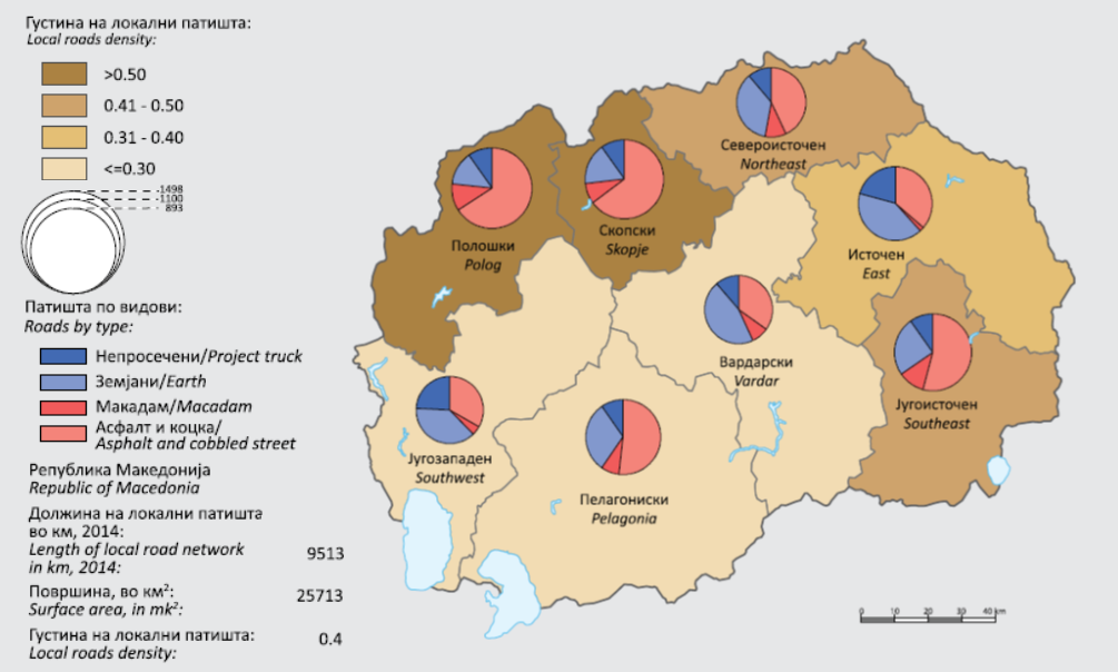
Source: State Statistical Office, The Regions in the Republic of Macedonia, 2015.
The review below names all the roads in the South-Eastern region.
Table: A – Roads (highways, express roads, arterial roads)
|
No. |
Name |
Route |
|---|---|---|
|
1 |
A1 |
Border crossing with R. Serbia (“Tabanovce”) – Kumanovo – Veles – Negotino – Demir Kapija – Gevgelija – border crossing with R. Greece (“Bogorodica”) and section Gradsko – Prilep (connection with A2) |
|
2 |
A4 |
Border crossing with R. Kosovo (“Blace”) – crossroad Stenkovec – ring road Skopje – Petrovec – Miladinovci – Sveti Nikole – Shtip – Radovish – Strumica – border crossing with R. Bulgaria (“Novo Selo”) |
Table: Р1 – Regional roads
|
No. |
Name |
Route |
|---|---|---|
|
1 |
P1103 |
Border crossing with R. Serbia (“Tabanovce”) – Kumanovo – Veles – Negotino – Demir Kapija– Gevgelija – border crossing with R. Greece (Bogorodica) and section Gradsko – Prilep (connection with A2) |
|
2 |
P1102 |
Border crossing with R. Kosovo (“Blace”) – crossroad Stenkovec – ring road Skopje – Petrovec– Miladinovci – Sveti Nikole – Shtip – Radovish – Strumica – border crossing with R. Bulgaria (“Novo Selo”) |
|
3 |
P1105 |
Davidovo (connection with P1102) – Udovo (connection with A1) – Valandovo – Rabrovo – Dojran – border crossing with R. Greece (Sretenovo) and section Star Dojran – border crossing with R. Greece (Nikolikj) |
|
4 |
P1108 |
Gevgelija (connection with P1102) – Moin - Konsko – Smrdliva Voda – SC Kozuf |
|
5 |
P1109 |
Gevgelija (connection with A1) – Bogdanci – Furka (conenction with P1105) |
|
6 |
P1302 |
Delchevo (connection with A3) – Pehchevo – Berovo – Dabile (connection with A4) |
|
7 |
P1310 |
Radovish (connection with A4) – Podaresh – Vladimirovo (connection with P1302) – Berovo –border with R. Bulgaria (GP Klepalo) |
|
8 |
P1401 |
Strumica (connection with A4)- Rabrovo – Valandovo – Balinci – Marvinci (connection with A1) |
|
9 |
P1402 |
Strumica (connection with A4)- Rabrovo – Valandovo – Balinci – Marvinci (connection with A1) |
|
10 |
P1403 |
Connection with A4 – Radovish – Vladevci – Vasilevo – Strumica (connection with A4) |
Table: Р2 – Regional roads
|
No. | >
Name |
Route |
|---|---|---|
|
1 |
P2431 |
Radovish (connection with P1310) – Plachkovica – Argulica (connection with P2334) |
|
2 |
P2432 |
Strumica (connection with A4) – Veljusa – Vasilevo (connection with P1403) |
|
3 |
P2433 |
Radovish (connection with A4) – Konche – Zagorci – Leskovica (conenction with P1103) – Selce –Sofilari (connection with A4) |
|
4 |
P2434 |
Connection with P1401 – Rich – connection with P2433 |
Table: Р29 – Regional roads
|
No. |
Name |
Route |
|---|---|---|
|
1 |
P29177 |
Connection with A1 - Miravci |
|
2 |
P29471 |
Podaresh (connection with P1310) – Jargulica – Pokrajchevo – Zleovo – Radichevo – (connection with A4) |
Table: Local road network 2010-2014 (km)
|
Republic of Macedonia |
South-Eastern Region | |
|---|---|---|
|
2010 |
9.252 |
969 |
|
2011 |
9.300 |
977 |
|
2012 |
9.355 |
957 |
|
2013 |
9471 |
888 |
|
2014 |
9513 |
893 |
Source: State Statistical Office, The Regions in the Republic of Macedonia, 2015